Platforms for the visualisation, processing and analysis of Mobility data in real time are becoming one of the tools most in demand by traffic and transport authorities and operators, at both the interurban and urban level. And no wonder.
The wave of digitalisation on which we are sailing is also affecting the field of mobility and the transport of goods and passengers. This has meant that terms such as Big Data, Artificial Intelligence, Machine Learning and Data Mining have burst into our daily lives, and we have of course incorporated them as fundamental tools in our products and services.
We highlight here Big Data, understood as sets of data drawn from different sources and in different formats, which are generated at high speed and therefore represent large volumes of information. Artificial Intelligence (AI) is a field of computer science that seeks to give machines and their systems the ability to mimic the cognitive abilities of people, granting them the ability to carry out complex tasks autonomously, learn from previously executed processes and adapt to different situations.
All these technologies push us to innovate and generate new solutions that we offer to our customers, to whom we propose applications that may be of interest. But are they mainly concepts that serve to appear modern or are they really technological tools that add value to the products and services we provide?
AI plays a central role in mobility data analysis platforms. By applying advanced techniques such asMachine LearningandData Mining, we enable our platforms to discover patterns, identify trends and generate valuable insights from large volumes of data.
We use these Platforms to provide such bodies, and specifically their managers and technical staff, with a clearer and more precise vision of what is happening on their roads and infrastructures, so that they can make informed decisions in order to achieve the objectives they have previously set. And so we begin the design process with this question: how do we intend to use the information generated by the Platform?
The mere visualisation of real-time data in an intuitive, geo-referenced manner, with interactive dashboards and the possibility of interlinking data from different sources, already offers great help in data management. But we don’t stop there. With our support, they establish the objectives for which the Platform will be used and on the basis of which we design the necessary data sources or the user interface in terms of scaling.

The data
Adapting the classic refrain, we could say that Platforms without data are just software, and data without Platforms are just numbers. Once the client’s objectives have been defined, we establish the data that we must and can integrate into the platform. Firstly, we have the data whose ownership or operation depends on the organisation itself, and which thus does not need to be obtained from third parties: physical or digital gauges installed on the roads such as loops, rubber strips, Bluetooth detectors or image analysis; air quality sensors; data from other applications such as accidents, road surface condition, physical attributes of the roads, actions on the roads (works or incidents); Floating Car Data from vehicles in the organisation’s fleet.
Taking this as out starting point, we aggregate data affecting mobility that other public entities make available to third parties on an open data basis: National Access Point for Traffic and Mobility, Open Data Mobility of the MITMA (Ministry of Transport, Mobility and Urban Agenda), DGT 3.0, weather information from the AEMET, data from public transport authorities and operators, local entities, etc.
But where we really take a leap forward in the quality of our platforms is the real-time information that comes from the road users themselves: anonymised data from mobile phones provided by operators, GPS positioning of car navigation systems, validation of public transport cards or mobile applications. The key player among all these factors, though, and the one that will predominate in the years to come, is the connected vehicle.
This connectivity of the vehicles on the roads is characterised by the fact that they have an internet connection that allows them to send the data they collect in real time. The data provided by such vehicles includes some that provide us with very valuable information that we integrate within the platforms: location, speed, use of brakes, operation of wheels and shock absorbers, activation of emergency lights or windscreen wipers. We convert this data into information on road bed and surface conditions, travel times, weather events, congestion levels or accidents. And all in real time.
It is important to collect and store data in an orderly and judicious manner. In the process known as ETL (Extract, Transform and Load), we design algorithms to extract the data from each source, transform them into formats interpretable by our platform, and load and store them in databases that can be consulted and even downloaded by third parties if the client so wishes.
Information visualisation: SICE proposition
SICE has such platforms and dashboards that exploit data by using the necessary and appropriate tools for each situation.
The Platforms have different user profiles, depending on the permissions and reading and/or modification rights to be established.
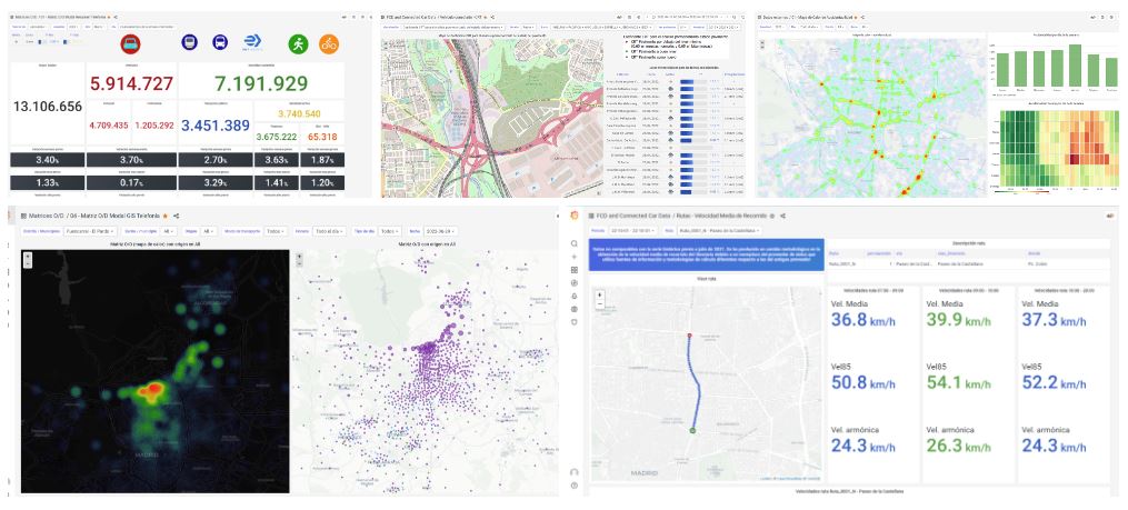
To begin with, we have the visualisation of information via modules, graphs and interactive dashboards, all with underlying cartography that allows the geo-referencing of the data and the events that we collect. Optimised graphs are generated in each case to show high-value information depending on the type of data to be represented: bar, scatter, pie, line, area or histograms. Heat maps are another highly valued tool for the visual representation of intensities of a given variable in a table, to highlight patterns and correlations in an efficient manner.
Meanwhile, we establish the automatic generation of reports based on the client’s needs, and can configure the indicators and data to be shown, the frequency of generation, or establish limits on the data to be generated (for example if a certain data point lies outside defined limits), alongside other aspects that help the client undertake its functions.
We can thus assert that our Big Data Platforms allow our clients to advance from DATA to KNOWLEDGE, analysing Mobility in an innovative and different manner, able to make informed decisions with an overall perspective and the focus on achieving their objectives. SICE has a specialised department with expert staff in the design and development of platforms and in the integration, management, interpretation and operation of the different types of data mentioned.